Tag Archives: news

  • -

RAQ: How To Get The Newest Data First

Tags : 

RAQ: How To Get The Newest Data FirstIs it ready yet? …How about now? …Now?

The aerial imagery collection window in Ontario is short for the most popular leaf-off ortho products, around 6-8 weeks. Typically we can start flying in late March and it all wraps up by early May, weather dependent. In this time frame we cover a lot of ground, often capturing imagery for several municipalities.

Once the intense flying season is over, the next six months are spent back at the office processing the raw images into an application-ready mosaic and posting the data to the MapWarehouse store, VuMAP, and MapCast.

During this six month period we frequently get asked, "Is it ready yet? …How about now? …Now?" There are three ways you can keep in the loop when new data is released.

Keep Reading »


  • 0

A Planet Sized Data Delivery

Tags : 

A Planet Sized Data DeliveryIntroducing Our Newest Data Partner: Planet Labs Geomatics

There's a million new reasons to choose MapWarehouse. First Base Solutions has entered a new reseller agreement with Planet Labs Geomatics, a provider of commercial satellite imagery, to bring over 1,000,000 square km of new Ontario imagery to MapWarehouse, and that's just the beginning!

Keep Reading »


  • 0

FBS Year In Review 2016

Tags : 

FBS Year In Review 2016Another year has flown by quickly

At First Base Solutions, we're wrapping up our 16th year of serving Ontario's top companies with aerial imagery and geographic services. Here's just a few of the highlights:

Jet Setting

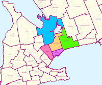
We've upgraded our technology with a new camera! We were busy flying and collecting aerial imagery around the GTA including Simcoe, Peel, York, Toronto, and Durham. The new imagery is available for sale on MapWarehouse and added to the collections in VuMAP.

FBS Year In Review 2016
New 2016 Aerial Imagery Coverage

Read more »


  • 0

LiDAR Provider Airborne Imaging Partners With FBS

Tags : 

LiDAR Provider Airborne Imaging Partners With FBS

LiDAR Elevation Models Coming To MapWarehouse

First Base Solutions is pleased to announce we have recently entered a data provider agreement with Airborne Imaging Inc. Since 2004, Airborne has collected LiDAR (Light Detection And Ranging) elevation data across Canada and the United States for use in oil and gas, mining, legal survey, engineering, power, and government sectors.

Read more »


  • 0

J.D. Barnes Acquires Black, Shoemaker, Robinson & Donaldson

Tags : 

J.D. Barnes Acquires Black, Shoemaker, Robinson & DonaldsonNew merger enhances services to Guelph area clients

 
We are pleased to announce that J.D. Barnes Limited has acquired Black, Shoemaker, Robinson & Donaldson Limited, effective October 31, 2016. Serving Guelph and surrounding regions, BSR&D Ltd. is a firm specializing in Land Surveying and Land Use Planning.

Read more »


  • 0

Our Newest High Value Data Partner, Tarin Resources Services

Tags : 

Our Newest High Value Data Partner, Tarin Resources Services

East Meets West

First Base Solutions is pleased to announce we have recently entered a partnership with Tarin Resources Services of Alberta.  In the coming months, First Base customers will see Tarin's aerial imagery covering Alberta added to our MapWarehouse store and MapCast WMS alongside our own Ontario data sets.

Read more »